Log in
All resources
Create a design
204 Free Images of Maps Of Straits
bibliothèque nationale de france
eran laor cartographic collection
jodocus hondius ii, nova totius terrarum orbis geographica ac hydrographica tabula, 1636
national library of israel
world map
jodocus hondius ii
maps of the magellan straits by lambert cornelis
map of the bosphorus strait by guillaume sanson (1665)
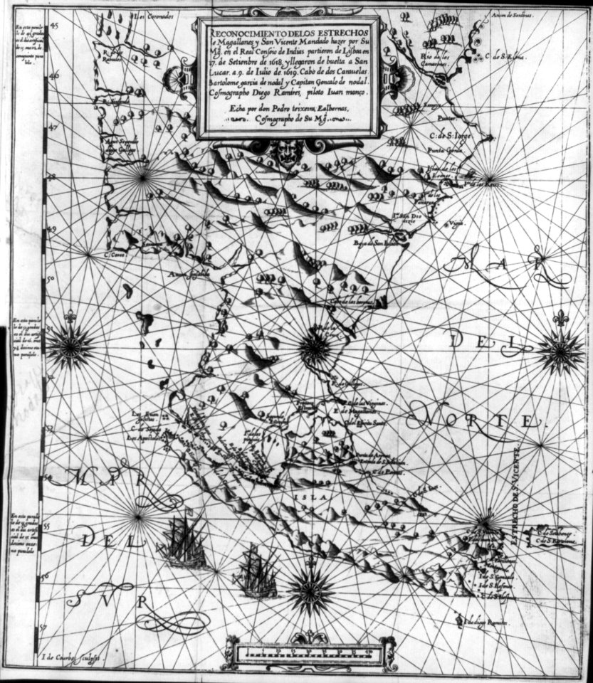
17th-century maps of the strait of magellan
map of the strait of kerch by guillaume sanson
maps from the earth and its inhabitants, vol. vii
1884 maps of taiwan
maps of the magellan straits by lambert cornelis
bibliothèque nationale de france
old maps of the bay of gibraltar
18th-century maps of gibraltar
17th-century maps of the strait of magellan
1640 maps of south america
historical
history
19th-century maps of the black sea
g. h. swanston
maps of the magellan straits by lambert cornelis
maps in the library of congress
maps of the strait of dover
cartes de franz schrader
map of the bosphorus strait by guillaume sanson (1665)
bibliothèque nationale de france
17th-century maps of the strait of magellan
maps by willem and johannes blaeu
old maps of the bay of gibraltar
18th-century maps of gibraltar
map of the bosphorus strait by guillaume sanson (1665)
bibliothèque nationale de france
maps by willem and johannes blaeu
1610s maps of the americas
picturesque journey to the two americas, asia and africa
1842 in bolivia
map of the bosphorus strait by guillaume sanson (1665)
bibliothèque nationale de france
map of the bosphorus strait by guillaume sanson (1665)
bibliothèque nationale de france
jodocus hondius ii, nova totius terrarum orbis geographica ac hydrographica tabula, 1636
eran laor cartographic collection
jodocus hondius ii, nova totius terrarum orbis geographica ac hydrographica tabula, 1636
eran laor cartographic collection
jodocus hondius ii, nova totius terrarum orbis geographica ac hydrographica tabula, 1636
eran laor cartographic collection
maps of the magellan straits by lambert cornelis
atlas minor gerardi mercatoris (1621, maps)
jodocus hondius ii, nova totius terrarum orbis geographica ac hydrographica tabula, 1636
eran laor cartographic collection
jodocus hondius ii, nova totius terrarum orbis geographica ac hydrographica tabula, 1636
eran laor cartographic collection
maps of the history of morocco
empire of morocco
map of the bosphorus strait by guillaume sanson (1665)
bibliothèque nationale de france
18th-century maps of the mediterranean sea
1745 maps
city gates of calais
citadelle de calais
a history of land mammals in the western hemisphere (1913)
map of the strait of kerch by guillaume sanson
bibliothèque nationale de france
old maps of the strait of gibraltar
a school geography (1898) by bird
the british monarchy (1743)
maps in the british museum
map of the strait of kerch by guillaume sanson
bibliothèque nationale de france
jodocus hondius ii, nova totius terrarum orbis geographica ac hydrographica tabula, 1636
eran laor cartographic collection
jodocus hondius ii, nova totius terrarum orbis geographica ac hydrographica tabula, 1636
eran laor cartographic collection
jodocus hondius ii, nova totius terrarum orbis geographica ac hydrographica tabula, 1636
eran laor cartographic collection
jodocus hondius ii, nova totius terrarum orbis geographica ac hydrographica tabula, 1636
eran laor cartographic collection
jodocus hondius ii, nova totius terrarum orbis geographica ac hydrographica tabula, 1636
eran laor cartographic collection
jodocus hondius ii, nova totius terrarum orbis geographica ac hydrographica tabula, 1636
eran laor cartographic collection
jodocus hondius ii, nova totius terrarum orbis geographica ac hydrographica tabula, 1636
eran laor cartographic collection
eran laor cartographic collection
pierre mortier
jodocus hondius ii, nova totius terrarum orbis geographica ac hydrographica tabula, 1636
eran laor cartographic collection
jodocus hondius ii, nova totius terrarum orbis geographica ac hydrographica tabula, 1636
eran laor cartographic collection
maps by pieter mortier
maps from gallica
maps from the earth and its inhabitants, vol. xiv
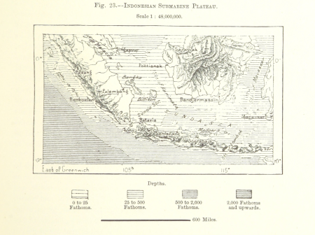
maps of the sunda strait
18th-century maps of the malay archipelago
18th-century maps of southeast asia
jodocus hondius ii, nova totius terrarum orbis geographica ac hydrographica tabula, 1636
eran laor cartographic collection
1740s maps of the world
maps by emanuel bowen
map of the strait of kerch by guillaume sanson
bibliothèque nationale de france
map of the bosphorus strait by guillaume sanson (1665)
bibliothèque nationale de france
map of the strait of kerch by guillaume sanson
bibliothèque nationale de france
historical
history
admiralty charts region b: england wales ireland english channel southern north sea
admiralty charts 1401-1600
old maps of tierra del fuego
description de l'universe
eran laor cartographic collection
isaak tirion
the comprehensive history of england (1876)
english-language maps showing history
the comprehensive history of england (1876)
english-language maps showing history
géographie générale; physique, politique et économique (1876)
old maps of the strait of gibraltar
agustín esteve
oil on canvas
map of the strait of kerch by guillaume sanson
bibliothèque nationale de france
atlas sive cosmographicae (gerardus mercator, 1607)
maps of the magellan straits by lambert cornelis
maps from the earth and its inhabitants, vol. iv
menai strait
17th-century maps of the strait of magellan
1668 maps of south america
maps of the magellan straits by lambert cornelis
atlas minor gerardi mercatoris (1614, maps)
maps from the earth and its inhabitants, vol. xiv
1890s maps of indonesia
the comprehensive history of england (1876)
english-language maps showing history
maps from the earth and its inhabitants, vol. xiv
1870s maps of indonesia
maps from the earth and its inhabitants, vol. xiv
1870s maps of indonesia
18th-century maps of gibraltar
maps by tomas lopez
atlas sive cosmographicae (gerardus mercator, 1623)
maps of the magellan straits by lambert cornelis
atlas sive cosmographicae (gerardus mercator, 1630)
maps of the magellan straits by lambert cornelis
bibliothèque nationale de france
guillaume sanson
travel
maps
atlas sive cosmographicae (gerardus mercator, 4th edition 1613)
maps of the magellan straits by lambert cornelis
mappa fluminis dicti vulgo beldt, cum omnibus littoralibus oris, limitibus, situsque terrarum vulgo dictarum lalandiae usque ad stephani caput - lucas ioanß wagenaer inventor ; ioannes à doetecum fecit - btv1b53235834g
bibliothèque nationale de france
mappa fluminis dicti vulgo beldt, cum omnibus littoralibus oris, limitibus, situsque terrarum vulgo dictarum lalandiae usque ad stephani caput - lucas ioanß wagenaer inventor ; ioannes à doetecum fecit - btv1b53235834g
bibliothèque nationale de france
map of the bosphorus strait by guillaume sanson (1665)
bibliothèque nationale de france
mappa fluminis dicti vulgo beldt, cum omnibus littoralibus oris, limitibus, situsque terrarum vulgo dictarum lalandiae usque ad stephani caput - lucas ioanß wagenaer inventor ; ioannes à doetecum fecit - btv1b53235834g
bibliothèque nationale de france
atlas ou representation du monde universel t. 2 (1633)
17th-century maps of the strait of magellan
18th-century maps of the bosphorus
joseph roux
maps of hormuz by braun & hogenberg
hebrew university of jerusalem
iceland
maps
iceland
maps
maps by jakob van der schley
history of hormuz island
cartouches by joseph roux
cartouche (cartography)
historical
history
1650s maps of the americas
1658 maps
nature
maps
1740s maps of the americas
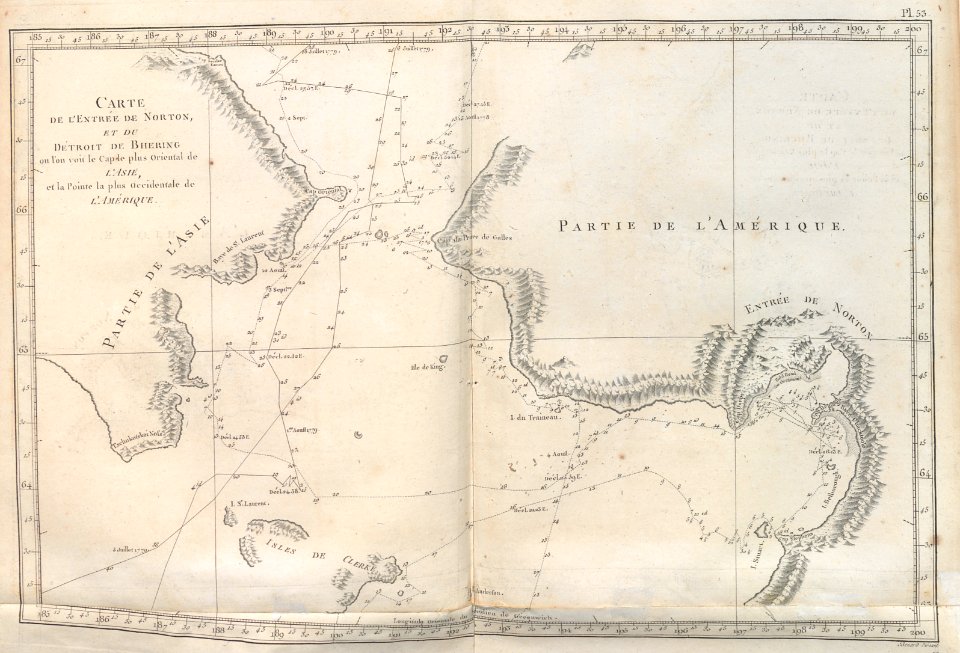
1747 maps of north america
zee caerte vande sondt t'vermaerste van denemarcken also tlandt aen beijde zijden int wesen ende gedaente is, alsmen daer mijdden doer zeijlt van waersbergen tot falsterboen toe, alwaer de ooster zee... - btv1b532358331
bibliothèque nationale de france
old maps of the strait of gibraltar
maps in the rijksmuseum amsterdam
canalis celebris vel navigationis à bristovio, atque totius situs inter galliam belgicam et britanniam accurata delineatio, eiusdemque terrae verus vultus cum suis miliaribus, ventis ac ascendentibus -... - btv1b53225454g
bibliothèque nationale de france
zee caerte vande sondt t'vermaerste van denemarcken also tlandt aen beijde zijden int wesen ende gedaente is, alsmen daer mijdden doer zeijlt van waersbergen tot falsterboen toe, alwaer de ooster zee... - btv1b532358331
bibliothèque nationale de france
zee caerte vande sondt t'vermaerste van denemarcken also tlandt aen beijde zijden int wesen ende gedaente is, alsmen daer mijdden doer zeijlt van waersbergen tot falsterboen toe, alwaer de ooster zee... - btv1b532358331
bibliothèque nationale de france
canalis celebris vel navigationis à bristovio, atque totius situs inter galliam belgicam et britanniam accurata delineatio, eiusdemque terrae verus vultus cum suis miliaribus, ventis ac ascendentibus -... - btv1b53225454g
bibliothèque nationale de france
canalis celebris vel navigationis à bristovio, atque totius situs inter galliam belgicam et britanniam accurata delineatio, eiusdemque terrae verus vultus cum suis miliaribus, ventis ac ascendentibus -... - btv1b53225454g
bibliothèque nationale de france
istanbul in the 1750s
maps by john rocque
beschrijvinghe van de zee custen van vlanderen, ende picardien, beghijnnende van nijeupoort tot diepen, met de vlaemsche bancken, begrepen de engte tusschen engelandt ende vranckrijk, twelckmen de hooffden... - btv1b53211568c
bibliothèque nationale de france
historical
history
beschrijvinghe van de zee custen van vlanderen, ende picardien, beghijnnende van nijeupoort tot diepen, met de vlaemsche bancken, begrepen de engte tusschen engelandt ende vranckrijk, twelckmen de hooffden... - btv1b53211568c
bibliothèque nationale de france
beschrijvinghe van de zee custen van vlanderen, ende picardien, beghijnnende van nijeupoort tot diepen, met de vlaemsche bancken, begrepen de engte tusschen engelandt ende vranckrijk, twelckmen de hooffden... - btv1b53211568c
bibliothèque nationale de france
french-language maps of north america
1809 maps of north america
101 - 200 of 204
Next page
/ 3


![Anaplus Bosphori Thracii / ex indagationibus Petri Gyllii; delineatus [a] Gulielmo Sanson..., 1665](https://cdn.creazilla.com/illustrations/10001604206/anaplus-bosphori-thracii-ex-indagationibus-petri-gyllii-delineatus-a-gulielmo-sanson-1665-sm.jpg)


![Bosphorus Cimmerius et regnum bosphoranum / ex collectionibus... Gulielmi Sanson... Mille passus 30 [= 0m.064]; stadia 200, 1665](https://cdn.creazilla.com/illustrations/10001442695/bosphorus-cimmerius-et-regnum-bosphoranum-ex-collectionibus-gulielmi-sanson-mille-passus-30-0m-064-stadia-200-1665-md.jpg)


![Bosphorus Cimmerius et regnum bosphoranum / ex colectionibus... Gulielmi Sanson... Mille passus [= 0m.064]; studia 200, 1665](https://cdn.creazilla.com/illustrations/10001580087/bosphorus-cimmerius-et-regnum-bosphoranum-ex-colectionibus-gulielmi-sanson-mille-passus-0m064-studia-200-1665-md.jpg)


![Gerardi Mercatoris and I. Hondii Atlas or Representation of the Universal World, and of the Parts of It, Made in Tables and Very Ample Descriptions. [t. 2].](https://cdn.creazilla.com/illustrations/10001243780/gerardi-mercatoris-and-i-hondii-atlas-or-representation-of-the-universal-world-and-of-the-parts-of-it-made-in-tables-and-very-ample-descriptions-t-2-sm.webp)